What is meaning of Chart Datum or CD and Lowest Astronomical Tide or LAT ?
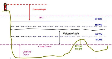
Chart Datum is the plane below which all depths are published on a navigational chart. It is also the plane to which all tidal heights are referred, so by adding the tidal height to the charted depth, the true depth of water is determined.
By international agreement, Chart Datum is defined as a level so low that the tide will not frequently fall below it. In the United Kingdom, this level is normally approximately the level of Lowest Astronomical Tide. Chart Datum is shown on charts as the zero metre contour
Most authorities use a datum called chart datum (CD), which to all intents and purposes is the lowest astronomical tide (LAT) for that length of coastline or that particular port.For navigation purposes any water depth has to be referenced to a common datum for it to have any meaning.
However, MLLW may be used as the tidal datum for tidal curves in the United States of America and is not as low as lowest astronomical tide.
The reason for using LAT is that there will always be at least the depth shown by the soundings, even at low water. Any higher datum will inevitably mean that sometimes there will be less water than the charted depth.
Note:
- There is a common misunderstanding that chart datum is constant for the whole of a chart, but this is not so.
- Coastal effects could cause the lowest astronomical tide to be significantly different at two places close together on the same chart.
Important Terms related to Chart Work – Chart Datum (CD) and Lowest Astronomical Tide (LAT)
Chart Datum (CD) and Lowest Astronomical Tide (LAT) are two important terms used in nautical charts and tide predictions.
What is Chart Datum (CD)
Chart Datum (CD) is the reference level used to measure the depths and heights shown on nautical charts. It is the level below which all soundings and depths are given, and it is determined by local authorities based on the mean sea level at the location in question. Chart Datum is used as a reference level to ensure that mariners have a consistent and accurate understanding of the water depths in the area.
What is Lowest Astronomical Tide (LAT)
Lowest Astronomical Tide (LAT) is the lowest level that the sea is predicted to reach under normal astronomical conditions, meaning when there are no storm surges or other weather-related effects. LAT is typically used as a reference level to determine the minimum depth of water available at a particular location, such as for ship navigation or dredging operations. LAT is calculated using data on tidal patterns and astronomical factors such as the positions of the sun and moon.
It is important for mariners and other users of nautical charts to understand these terms and their meanings to ensure that they have an accurate understanding of the water depths and tidal conditions in a given area. Additionally, it is important to note that these values may change over time due to factors such as sea level rise or changes in tidal patterns, so it is important to consult updated charts and tide tables to ensure the most accurate and up-to-date information.